

Understanding Airspace for the Part 107 Exam (With Real Examples)
Airspace doesn't have to be an invisible mystery. Once you see the matrix, you can't unsee it.
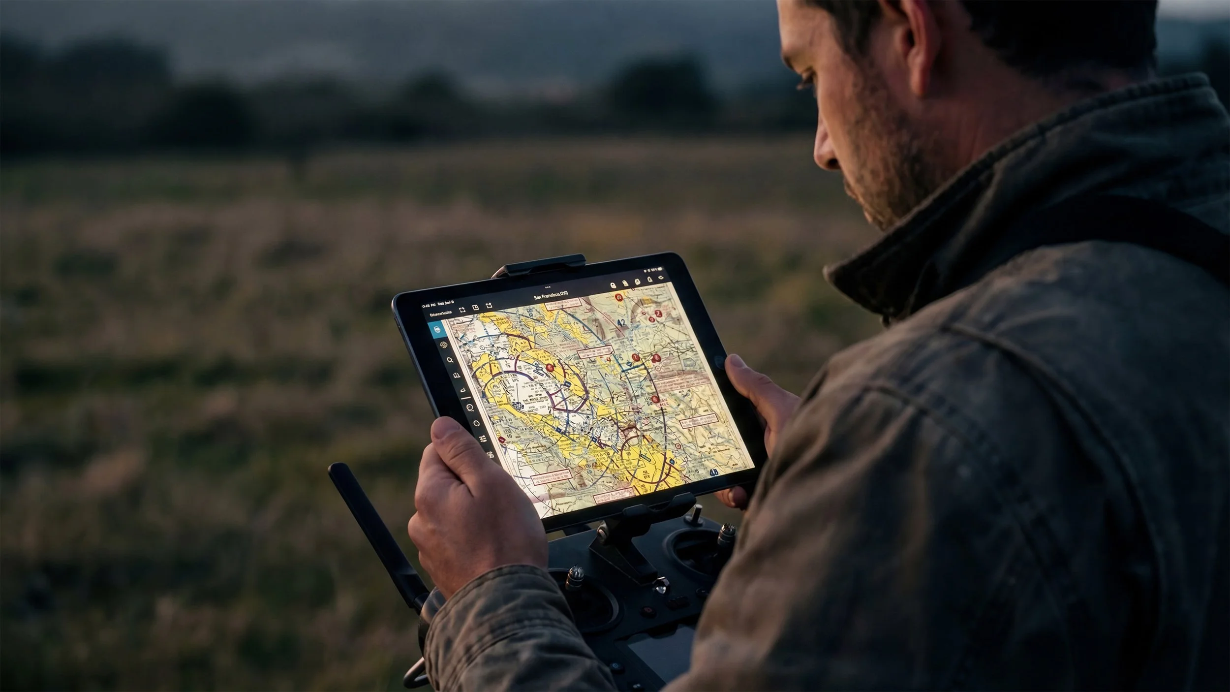
Introduction: The Sectional Chart Shock
Airspace is the single biggest source of confusion on the FAA Part 107 exam.
It looks complicated. It feels deeply technical. And if you’ve opened an aviation sectional chart for the first time, you probably stared at the mess of magenta lines, blue circles, and numbers and thought:
"What am I even looking at?"
That’s the usual response when seeing a section chart like the one below for the first time.
Sectional Chart Excerpt of the San Francisco Bay Area. (Source: FAA-CT-8080-2H, Figure 74)
The good news? Airspace is highly structured. It follows strict rules. And once you understand the pattern behind the madness, it becomes entirely predictable. You don’t need a degree in cartography to figure this out; you just need the decoder ring.
This guide will break down the difference between controlled and uncontrolled airspace, what each class actually means, how to read it on a chart, and most importantly—how this applies to your real-world drone operations.
Part 1: What Exactly Is Airspace?
Airspace is simply how the FAA organizes the sky.
Airspace Profile (FAA-G-8082-22, Figure 2-1.)
Think of it like driving. Just like roads have speed limits, stoplights, and multi-lane highways, the sky has structure. That invisible structure exists to:
Separate aircraft (so a Cessna doesn't hit a Boeing 737).
Protect airport operations (where planes are taking off and landing).
Maintain safe altitude buffers.
Prevent conflicts between manned aircraft and drones.
For drone pilots, knowing your airspace determines three critical things:
Whether you can fly immediately.
Whether you need to ask the FAA for authorization first.
What your specific altitude limits are for that location.
Part 2: Controlled vs. Uncontrolled Airspace
Before we get into the alphabet soup of airspace classes, let's look at the simplest breakdown possible:
Controlled Airspace = The FAA is actively managing traffic here. ATC (Air Traffic Control) is in charge.
Uncontrolled Airspace = The FAA does not actively manage traffic here. You are on your own to see and avoid hazards.
The Golden Rule for Part 107 Pilots: If you want to fly in surface-based Controlled Airspace, you almost always require authorization (usually obtained in seconds via an app called LAANC). If you fly in Uncontrolled Airspace, you do not need pre-approval, though all standard Part 107 safety rules still apply.
Prefer audio? Listen to the full podcast breakdown below or open the episode page.
Part 3: The Airspace Classes You Must Know
Under Part 107, you don't need to worry about Class A (that's for commercial jets flying above 18,000 feet). You need to focus on B, C, D, E, and G.
If you're new to Part 107 altogether, start with our guide on who needs Part 107 and how to qualify.
Class B (Busy Major Airports)
Think of the biggest airports in the country: LAX, JFK, Atlanta, O'Hare.
The Vibe: Highly structured, extremely busy.
The Shape: Multiple altitude layers that look like a massive, upside-down wedding cake.
The Rule: You always need authorization to fly here.
Class B (Solid Blue): In the sectional chart below, find the solid blue rings around the Dallas Fort Worth Airport. These rings represent Class B airspace. Notice the multiple rings indicating different altitude shelves.
Sectional Chart Excerpt of Dallas / Fort Worth Area. (Source: FAA-CT-8080-2H, Figure 25)
Class C (Mid-Sized City Airports)
Think of regional or mid-sized city airports.
The Vibe: Busy, but not chaotic.
The Shape: A simpler two-layer "upside-down wedding cake" shape. It usually has an inner circle and an outer shelf.
The Rule: Authorization is required to fly here.
Class C (Solid Magenta): Take a look at the sectional chart below and look for the Solid Magenta rings around the Mid-sized airport at the bottom of the chart. That’s Class C airspace. Class C usually features an inner core and a single outer shelf.
Sectional Chart Excerpt (Source: FAA-CT-8080-2H, Figure 21)
Class D (Smaller Towered Airports)
These are smaller, local airports that still have an operational control tower.
The Vibe: Local traffic, student pilots, private jets.
The Shape: A simple cylinder. It doesn't have shelves. Usually extends from the surface up to around 2,500 ft AGL (exact ceiling shown on the chart).
The Rule: Authorization is required.
Class D (Dashed Blue): In the below sectional chart, look for the dashed blue circle toward the bottom of the chart. That represents Class D airspace. This simple cylinder of airspace protects a smaller towered airport.
Sectional Chart Excerpt (Source: FAA-CT-8080-2H, Figure 20)
Class E (Controlled, But Often Not Surface-Based)
This is the one that confuses everyone. Class E is everywhere. It is the filler airspace.
The Catch: Class E often begins at 700 ft AGL or 1,200 ft AGL. Since drones max out at 400 ft AGL, you are usually flying underneath it (in Class G).
The Rule: If Class E starts at the surface (dashed magenta line), you need authorization. If it starts at 700 ft or higher, you do not need authorization.
Class E (Shaded Magenta): In the below sectional chart, look for the shaded magenta boundaries. That represents Class E airspace.
Sectional Chart Excerpt (Source: FAA-CT-8080-2H, Figure 21)
Class G (Uncontrolled)
This is the ground floor. It's the airspace closest to the dirt where the FAA doesn't provide radar tracking.
The Vibe: The Wild West (but with speed limits).
The Rule: No authorization required. This is where most commercial drone operations take place.
Part 4: Why the FAA Tests Airspace So Heavily
If you feel like the test is obsessed with airspace, you are right. But it isn't to torture you. Airspace knowledge equals collision avoidance.
On the Part 107 exam, you will be given a supplement book with real maps. You will see:
Sectional chart excerpts.
Questions asking, "What airspace is this?"
Questions asking whether authorization is required.
Questions asking for the maximum altitude in a specific grid.
The test is not asking you to memorize colors for the sake of art class. It is asking you to interpret structure so you don't accidentally fly your drone into the flight path of a medical helicopter. You’ll be given a legend like the one below to help you find some of the more obscure things on a sectional chart.
Sectional Chart Legend. (Source: FAA-CT-8080-2H, Figure 74)
Part 5: A Real-World Example
Let’s connect the textbook to the real world.
The Scenario: You are hired to photograph a new commercial construction site.
The Prep: You check your digital sectional chart (like the Air Control app).
The Discovery: You see the site is located inside a dashed blue circle. You know from your studying that this is Class D airspace.
The Action: Because it's controlled airspace, you cannot just launch your drone.
The Solution: You open your LAANC-approved app, select the grid square over the construction site, check the maximum altitude allowed (let's say it's 200 feet), and submit an authorization request.
The Result: You get a text message approving your flight in seconds. You fly legally and safely.
This is exactly why the FAA tests airspace. Real commercial operations require you to understand how to share the sky.
Part 6: The Pattern That Makes It Easy (Study Strategy)
Don't try to memorize the entire map. Look for the pattern. Airspace complexity follows airport complexity.
Massive Airport = Complex Airspace (Class B)
Medium Airport = Medium Airspace (Class C)
Small Towered Airport = Simple Airspace (Class D)
No Tower = No Active Control (Class G)
Once you internalize that pattern, the chart stops looking chaotic. It starts looking like a logical map of city limits.
How to prep for the exam:
Study one class at a time.
Look at 5–10 real sectional examples of that specific class.
Take scenario-based quizzes that force you to find a town on the map and identify its airspace.
Looking for more info on what to expect from the Part 107 exam in 2026? Check out our Complete Guide: How to Pass the FAA Part 107 Exam in 2026
Ready to stop guessing and start mastering the charts?
At Red Raven UAS, we have built the ultimate Part 107 Prep Course for 2026.
Up-to-Date: Fully updated for the latest Remote ID and Night Ops rules.
Real Scenarios: We don’t just teach the test; we teach you what you learn relates to real world flying.
Guarantee: We are so confident in our method that if you don't pass, we refund your course fee.
(Pass Guarantee terms apply.)
Don’t let the exam slow you down — let’s get you certified.
Watch: Red Raven Part 107 Course Overview
Part 107 Airspace FAQ
What airspace can I fly in under Part 107?
You can fly in Class G (uncontrolled) airspace without prior authorization (as long as you follow Part 107 rules). For controlled airspace (typically Class B, C, D, and the surface area of Class E), you generally need FAA authorization.
How do I know if airspace is controlled where I’m flying?
Use a current airspace tool (LAANC-enabled apps, sectional charts, or the FAA’s UAS Facility Maps). If you’re near an airport or the app shows grids with altitude limits, assume controlled airspace and verify before you fly.
What is LAANC and when should I use it?
LAANC (Low Altitude Authorization and Notification Capability) is the FAA’s system that allows many pilots to get near-real-time authorization to fly in controlled airspace at or below approved grid altitudes. Use LAANC when it’s available for your location and mission.
What are UAS Facility Maps (UASFM)?
UAS Facility Maps show the maximum altitude the FAA may approve for UAS operations in controlled airspace, displayed as grid squares around airports. LAANC apps use these grids to determine what can be automatically approved.
What if LAANC isn’t available or I need to fly above the grid altitude?
You’ll usually need to submit an authorization request through the FAA’s online portal (or your LAANC provider’s “further coordination” workflow when offered). These requests take longer and should be filed ahead of time.
Can I fly in Class B airspace with Part 107?
Yes—only with authorization and within the altitude limits you’re approved for. Class B tends to be the most restrictive, so approvals may be harder and more limited depending on the airport and location.
Does controlled airspace mean I have to talk to Air Traffic Control (ATC)?
Not usually for typical small UAS operations. Authorization is handled through LAANC or the FAA portal. However, some special authorizations or local procedures may include additional requirements—always follow what your approval says.
What is the difference between airspace authorization and a Part 107 waiver?
Authorization is permission to fly in controlled airspace (B/C/D/E surface). A waiver is permission to deviate from certain Part 107 rules (like night operations under older rules, operations over people, etc.). They’re different processes and not interchangeable.
What’s the biggest airspace mistake new Part 107 pilots make?
Assuming “I’m below 400 feet so I’m legal.” Airspace rules still apply at low altitude—especially near airports. Always check airspace and obtain authorization when required.
About Red Raven UAS
Red Raven UAS was founded by public safety and drone industry veterans who know what it takes to get certified and fly professionally. Our Part 107 online course was built by Derrick Ward — 35-year LAFD veteran and public safety UAS pioneer — and Michael Wilson, former Director at DJI. It cuts through the confusion of FAA manuals and scattered YouTube videos and gives you a clear, structured path to passing your exam on the first try — guaranteed. Whether you're a complete beginner or an experienced drone pilot finally going legit, we give you everything you need: study guide, practice tests, audio lessons, and an AI tutor available anytime. Pass the test, get your certificate, and start flying professionally with confidence.
Explore More